Overview
Ocean liners did not operate in an abstract “golden age” of travel. They existed
to serve specific corridors: mail routes, migration routes, imperial links,
prestige crossings, and long-distance passenger networks that reflected trade,
empire, and industrial power.
Some lanes rewarded speed and regularity. Others depended more on endurance,
cargo-passenger balance, or access to colonial and emigrant traffic. A ship’s form,
accommodations, and even reputation often make more sense once its intended route is understood.
This page is interpretive by design. It does not attempt to plot every liner route,
but instead outlines the major trade lanes that most clearly shaped passenger shipping history.
Primary focus
How major sea lanes shaped ocean liner design, service patterns, and historical importance.
Strongest corridor
The North Atlantic, especially the Europe–New York route, dominated prestige and public memory.
Other key systems
Empire routes, South American services, Mediterranean migration corridors, and long-distance Australasian services.
Main historical shift
The move from steamship dependence to aviation, which steadily weakened the old route structure after the Second World War.
Reviewed using curatorial standards
Timeline
1830s–1840s
Regular steam crossings begin to reorder Atlantic travel
Early steam services established the practical basis for scheduled transatlantic travel.
The route mattered more than luxury at this stage: reliability, mail carriage,
and the promise of more regular passage began to displace the older sailing packet world.
1850s–1870s
The North Atlantic becomes the dominant prestige lane
Links between Britain, continental Europe, and New York grew in commercial and symbolic importance.
This was the corridor on which shipping companies increasingly competed for visibility, speed, and reputation.
Other routes remained vital, but this lane became the public theater of liner rivalry.
1880s–1914
Migration corridors expand across the Atlantic and beyond
Passenger shipping was not only about elite travel. Vast numbers of migrants moved through
routes linking continental Europe, the British Isles, the Mediterranean, and the Americas.
This traffic reshaped ship accommodation planning, terminal logistics, and service frequency.
1890s–1914
Empire and long-distance services gain strategic weight
Routes connecting Britain to India, the Suez corridor, South Africa, Australia, and New Zealand
reinforced the role of liners in imperial communication. These were not simply passenger routes:
they were arteries of administration, status, mail, and commerce.
1914–1918
War disrupts the established route system
The First World War fractured normal passenger operations. Requisitioning, losses,
risk zones, and strategic shipping needs interrupted the peacetime geography of liner travel.
After the war, some lanes recovered quickly, but the system returned altered.
1920s–1930s
Prestige returns, but route hierarchies remain uneven
The interwar period revived the North Atlantic as the ceremonial center of liner competition,
while South American and Mediterranean services retained strong practical importance.
Different routes produced different ships: express Atlantic greyhounds, mixed-service liners,
and migrant or imperial carriers serving distinct passenger worlds.
1939–1945
Global war again overtakes normal passenger geography
The Second World War subordinated commercial route logic to military transport and strategic need.
The peacetime map of liner travel did not disappear completely, but it was no longer the controlling framework.
Late 1940s–1950s
Recovery brings one last great era of route-defined liner travel
Postwar rebuilding restored many famous services. The North Atlantic still mattered enormously,
but Australia, Africa, the Mediterranean, and South America also sustained important passenger operations.
The route map remained global even as its economic foundations were beginning to weaken.
Late 1950s–1960s
Air travel begins to collapse the old lane structure
Aviation reduced the practical necessity of long-distance liner passage, especially across the North Atlantic.
Routes once defined by schedule and prestige increasingly became uneconomic for regular passenger service.
The route system did not vanish overnight, but its logic was steadily undone.
1970s onward
The classic trade-lane world gives way to cruising and heritage memory
By this stage, many former liner routes had lost their original function as transportation corridors.
Surviving ships, where they remained in service, increasingly belonged to a different culture:
leisure cruising rather than scheduled point-to-point ocean passage.
Major Route Systems
↔
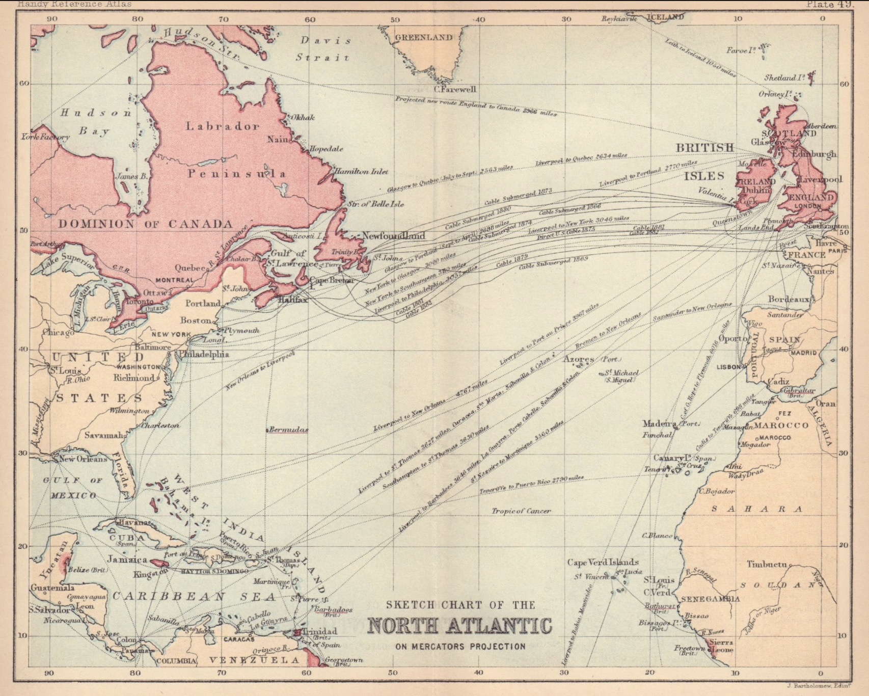
North Atlantic Express Route
The most famous liner corridor linked ports such as Southampton, Cherbourg, Hamburg,
Le Havre, and New York. This was the route of speed contests, blue-riband prestige,
and the ships most likely to dominate public memory.
⚓
Mediterranean & Migration Corridors
Routes through southern Europe and the Mediterranean served both migrants and regional passenger traffic.
These corridors complicate any history that focuses only on elite Atlantic travel.
Services to India, the Far East, and Australasia reflected imperial geography.
They depended on regularity, endurance, and mixed passenger functions rather than Atlantic-style speed spectacle alone.
⟡
South American Services
Routes to Brazil, Argentina, and the River Plate region supported business, migration,
and social travel. These lanes were commercially important and often produced elegant,
highly distinctive ships outside the usual Atlantic spotlight.
Route importance should not be confused with route fame. The most remembered lane is not always
the only one that mattered.
Why Routes Matter in Ship History
Speed followed route pressure
High-speed liners emerged where schedule prestige, mail contracts, and public rivalry rewarded speed.
Accommodation reflected traffic type
Ships serving migrants, imperial officials, tourists, or elite transatlantic travelers were not solving the same problem.
Fame distorts the map
A ship’s fame may reflect later memory more than the full commercial structure of passenger shipping.
Looking at routes also helps explain why ships from different lines can appear superficially similar
yet belong to very different service worlds. A prestigious North Atlantic express liner, an Australasian
route steamer, and a South American passenger ship might all be “ocean liners,” but their intended use,
schedules, and passenger mix were not interchangeable.
How to Read the Route Map Historically
A route map should be read as evidence of function. It tells you where a ship fit into a wider network of
trade, migration, communication, and prestige. It can also help avoid an overly romantic view of liner history.
Not every celebrated ship belonged to the most globally important route at every moment, and not every
commercially important route produced the ships best remembered in popular culture. That tension is part of the value of route history:
it restores structure where nostalgia often simplifies.
Ask first
What corridor was this ship actually built to serve?
Then ask
What kind of passenger traffic made that route viable?
Then compare
How did route demands shape speed, scale, comfort, and public image?
Sources & Notes
This page is a synthesis page rather than a route register. It is meant to provide a stable interpretive framework
for understanding ocean liner geography, not a complete list of every service pattern or port call.
- General histories of transatlantic and imperial passenger shipping.
- Line histories and published route maps from major passenger companies.
- Contemporary timetables, service announcements, and mail-route references where available.
- Secondary scholarship on migration, empire travel, and the transition from sea passage to aviation.
Curator-minded synthesis page